|
|
Loftus
Historical and geographical information
|
|
Dates
are in red.
Hyperlinks
to other pages are in dark
blue.
Headlines
of the history of the Loftus are in brown.
References
and citations are in turquoise.
Contextual
history is in purple.
This
webpage about the Loftus has the following section headings:
- The Farndales of Loftus
- Loftus, an overview
- Timeline of Loftus
- Notable people of Loftus
- Links,
texts and books
The Farndales of Loftus
The
Loftus
1 Line are the descendants of William Farndale (FAR00152),
1739 to 1813 who was a constable in Loftus and a freeholder. The
Loftus
2 Line are the descendants of George Farndale (FAR00350C),
1843 to 1917 who was a farmer in Brotton and Iron miner of
Loftus. The Loftus
3 Line are the descendants of William Farndale (FAR00378),
1849 to 1894, a farm servant of Loftus, Whitby and Egton.
Loftus
Loftus is recorded as "Lcotvsv"
in the Domesday book, from Laghthus meaning
low houses. Loctushum, Locteshusum (eleventh century); Lofthusum
(twelfth century); Lofthus (twelfth to fifteenth centuries); Loftous, Loftos
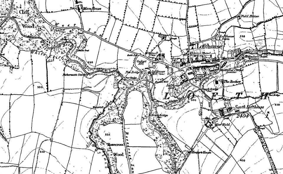
(thirteenth century); Lofthouse (thirteenth and fourteenth centuries).
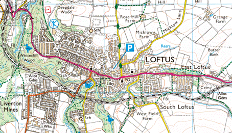
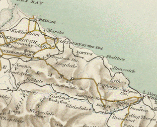
Loftus is a town and civil
parish located in the borough of Redcar and Cleveland in
the North East of England. The town lies within
the ceremonial county of North Yorkshire and is governed by
the unitary authority of Redcar and Cleveland. It lies in a
region between Saltburn-by-the-Sea and the North York Moors. It
was formerly known as Lofthouse. The population of the Loftus ward of
the Redcar and Cleveland unitary authority taken at the 2011
census was 6,382.
The Victoria County
History – Yorkshire, A History of the County of York North Riding: Volume 2
Parishes: Loftus, 1923: The parish contains
the market town of Loftus, and to the south the isolated farms of High and Low Wapley, with Gallihowe, Deepdale
and Street Houses to the north. Its area is 3,744 acres, of which 137 acres are
foreshore, 6 acres are covered by inland waters, 885 acres are arable land,
1,741 acres permanent grass and 457 acres woods and plantations. The whole
township is called Loftus, but, as in 1308–9, it is divided by a stream into
North Loftus and South Loftus.
The Methodist preacher John Wesley is
known to have preached in Loftus. More recent history is dominated by
the ironstone mining
industry and many inhabitants that live in Loftus can trace lineage back to
ironstone miners.
Loftus Timeline
200 CE
A Roman Villa has been unearthed on the
coast near Loftus.
Seventh Century
The Loftus area has been inhabited since at
least the 7th century, and although folkloric evidence includes a house owned
by Sigurd the Dane, who features in Macbeth as Siward, real
evidence has been unearthed in recent times to support the picture of ancient
settlement in the area.
The only known Anglo-Saxon royal
burial site in north-east England is near Loftus. Artefacts were
discovered there from excavations which took place between 2005 and 2007. Finds
include pieces associated with a rare bed burial in
which a decorated female body is laid out on a decorated wooden bed accompanied
by fine gold jewellery. The finds include a gold pendant, which would have
belonged to a princess. as well as glass beads, pottery, iron knives, belt
buckles and other objects. The finds, which date back nearly 1400 years were
discovered by members of the Teesside Archaeological Society, led by Dr Steve
Sherlock, in a 109-grave site at Street House, Loftus. They are presently on
show at the Kirkleatham Old Hall Museum.
In 2008 the local Archaeologist, Dr Stephen
Sherlock, discovered an Anglo-Saxon burial ground on the coast near Loftus.
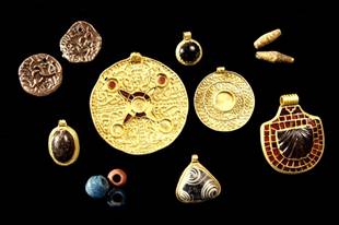
Items from an Anglo Saxon
burial site at Loftus
1086
There were two vills
of Loftus in 1086, each composed of 4 carucates of land. Before the Conquest
Siward Earl of Northumberland held 4 carucates here as a 'manor,' then worth
£48, but in 1086 waste.
1205
Peter de Brus offered 25 marks and a “palfrey” to have the seisin (conveyance
of ownership) of Lofthouse of the honour of Chester.
1615
The Victoria County
History – Yorkshire, A History of the County of York North Riding: Volume 2
Parishes: Loftus, 1923: Between 1615 and 1633
all the arable, meadow and pasture land in the common
fields and 'ings' of North Loftus was partitioned
among the farmers who had purchased the manor.
1657
The Victoria County
History – Yorkshire, A History of the County of York North Riding: Volume 2
Parishes: Loftus, 1923: Alum rock was
mentioned in a letter to Sir Thomas Chaloner in 1603–7, and alum works had been
started shortly before 1657–8 when the mine was let on a lease by the lord of
the manor, who leased it to the Crown for £400 yearly in 1665 and refused to
abate the rent to £300 per annum, despite the threats of Sir Anthony Ashley
Cooper.
1791
The Victoria County
History – Yorkshire, A History of the County of York North Riding: Volume 2
Parishes: Loftus, 1923: In 1791 Thomas
Richardson of Handale Abbey was rewarded by the
Society of Arts for having planted 40 acres of land with mixed timber which
still flourishes.
1808
The Victoria County
History – Yorkshire, A History of the County of York North Riding: Volume 2
Parishes: Loftus, 1923: It was stated in 1808
that a weekly market had been started recently and was a convenience to the
alum workers.
1831
The Victoria County History – Yorkshire, A History of the County of
York North Riding: Volume 2 Parishes: Loftus, 1923: A
decrease of 140 in the population in 1831 was ascribed to the depreciated state
of the alum works and consequent emigration to America.
1857
1861
The Victoria County
History – Yorkshire, A History of the County of York North Riding: Volume 2
Parishes: Loftus, 1923: The population is said
to have more than doubled in 1861–71 owing to the commencement of the iron
industry.
1874
The Oddfellows Hall, in Loftus, was built in
1874 as the offices and meeting place of the
local Oddfellows society. The Loftus Oddfellows would raise money for
their members.
Oddfellows were friendly or mutual
societies, set up and organised by people from different guilds representing
various trades. Other societies existed for single trades, but when there were
not enough people from one trade, especially in smaller towns, societies would
be formed from an "odd" mixture of people, so giving the name "Oddfellows".
1875
Loftus railway station opened in 1875. It closed to passengers in
1960. The line still operates through the station site, with freight services
for Boulby Mine, and occasional passenger 'specials'
for rail enthusiasts.
1879
Loftus Town Hall was built by the Earl of Zetland, erected by a
Thomas Dickenson of Saltburn, and was first opened in 1879. The Town Hall clock
has faces north, east and west, but no face to the
south as the residents of South Loftus were reluctant to contribute to the
cost.
1894
The Victoria County History – Yorkshire, A History
of the County of York North Riding: Volume 2 Parishes: Loftus, 1923: The urban district formed under the Local Government Act of 1894
comprises the parishes of Loftus, Liverton and Skinningrove. A pretty town, in spite of its mining industry, it has grown up round its
old High Street, in the centre of which are the Town Hall and church of St.
Leonard.
1962
To the north of the village there is a
disused nuclear bunker. The bunker was opened in
1962 and closed 1968.
Notable people of Loftus
Notable people include Lewis Hunton (1814–1838), geologist.
Links, texts and books