Huttons Ambo
Historical and geographical information
|
Return to the Home Page of the Farndale Family
Website |
The story of one family’s journey through two
thousand years of British History |
The 83 family lines into which the family is divided.
Meet the whole family and how the wider family is related |
Members of the historical family ordered by date of
birth |
Links to other pages with historical research and
related material |
The story of the Bakers of Highfields, the Chapmans,
and other related families |

Dates are in red.
Hyperlinks to other pages are in dark blue.
Headlines are in brown.
References and citations are in turquoise.
Contextual history is in purple.
This webpage
about the Huttons Ambo has the
following section headings:
·
Farndale
family history and Huttons Ambo
· Huttons Ambo,
overview
· Timeline of
Hutton’s Ambo history
· Bibliography
The Farndales of Sheriff
Hutton
There
is a significant branch of the
Ampleforth Line, particularly descending from William Farndale (FAR00286) who
lived in Huttons Ambo by 1871.
Huttons Ambo, overview
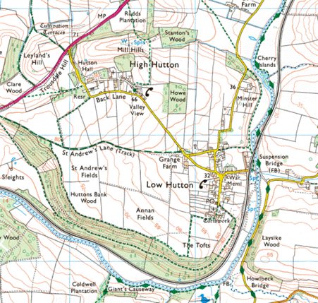
Huttons
Ambo is a civil parish in the Ryedale district of North Yorkshire. It is about
22 km north-east of York and 5 km) south-west of Malton. The civil parish of
Huttons Ambo consists of the villages of High Hutton and Low Hutton.
Huttons
Ambo is really two villages, High Hutton and Low Hutton. Ambo is latin for 'both', so Huttons Ambo means 'Both Huttons'.
Hutton, the toponym, derives from the Old English hōh
tūn, meaning settlement on or by the
hill spur. Ambo, the suffix, is Latin indicating the combination of the
two villages into the one parish.
In
the Medieval times Huttons Ambo consisted of three settlements, Hutton
Bardolf, Hutton Colswayn and Hutton Mynchon, which gradually evolved into the current two
villages.
Timeline of Hutton’s Ambo
history
Roman
Recent
excavations in Huttons Ambo (2023–2025) by Ethos Heritage CIC uncovered
significant Roman, Iron Age, and Medieval, finds, including thousands of
pottery sherds and evidence of a Romano-British settlement. Key discoveries
indicate a thriving rural site with high-status connections dating from 75 BCE
to 300 CE, plus later 4th-century finds.
Excavations in the 1950s
first identified Roman occupation at the South end of the village of Low Hutton
near the river, in the form of a ditch containing sherds of Crambeck
pottery and a coin of Constantine I, and structures such as ditches.
A geophysics survey
carried out in Huttons Ambo in 2023 found a large ditch and bank, and a trench
was placed inside it in July 2024. This uncovered large amounts of Iron Age and
Roman pottery, dating from 75 BCE to 300 CE. In addition, large circular pits
were also identified, suggesting that a Romano-British feature lies within this
bank and ditch.
Excavators have now
revisited the large medieval building uncovered the previous year and confirmed
that it dates back to the twelfth to thirteenth
centuries. The building reused Roman building stone, including what may be part
of a Roman column ahead. Pottery and coins from the late 4th century were also
found.
(Ryedale – somewhere a fort? Roman Yorkshire, newsletter of the Roman Antiquities
Section, 2026)
1086
Huttons
Ambo originally consisted of three manors Hutton Colswayn , Hutton Bardolf
and Hutton Mynchon, eventually these evolved into the
two villages existing today. It had been split into two main parts, even before
the time of the Norman Conquest.
The
villages of High and Low Hutton are mentioned in the Domesday book as Hotun
in the Bulford hundred. The lands were divided between Cnut, son of Karli,
Thorkil and Thorbrand son of Kalri.
After
the Norman invasion, the lands were split between the King and Berengar of
Tosny.
The Victoria County History – Yorkshire, A History of the
County of York North Riding: Volume 2 Parishes: Huttons Ambo, 1923: Two
'manors' in Hutton or Hutton-Upon-Derwent in the reign of Edward the Confessor
were held by Cnut and Torchil, and together were
assessed at 8½ carucates. In the Domesday Survey both are found among the lands
of the Conqueror. Five and a half
carucates afterwards came 'by the gift of a certain King of England' either to Colswayn or an ancestor of Colswayn
by the serjeanty of guarding the gate of York Castle.
The
land at Low Hutton owned by the King, has been named Hutton Colswayn,
whilst the land near Hutton Hill has been known as Hutton Mynchon. The land at High Hutton has been known as Hutton
Bardolf. All these suffixes indicate the names of the landowners of those
times.
The Colswayn family may have been given the land by the Crown
for duties performed guarding York Castle. The titles passed on to the Bolton
family.
The other
lands came into the possession of the Gower family, some of whom held the
office of High Sheriff of York, such as Sir Thomas Gower. Memorials to members
of this family can seen in the Church.
Thirteenth
century
The Victoria County History – Yorkshire, A History of the
County of York North Riding: Volume 2 Parishes: Huttons Ambo, 1923: In
the 13th century Hutton fell into the three main divisions of
Hutton-upon-Derwent (more often known as Colswayn
Hutton), Hutton Bardolf and Hutton Mynchon.
Excavations
in the 1950s revealed evidence of 12th- or 13th-century fortified buildings at
the south end of the village of Low Hutton near the river.
The Victoria County History – Yorkshire, A History of the
County of York North Riding: Volume 2 Parishes: Huttons Ambo, 1923: The
first tenant of whom any record has been preserved was the Colswayn,
who held it by serjeanty in the 12th century, and may himself have been the
original recipient of the royal gift. In 1261, when the serjeanty was claimed
for his descendant John Bolton, Colswayn's tenure was
declared to date from time immemorial. Possibly he was the heir of an earlier Colswayn, from whom both the serjeanty and
Hutton-upon-Derwent were sometimes named. Alan de Hutton, his son and heir,
alienated his inheritance to his cousin Ralph, son of Colswayn's brother
Bernard, who held the serjeanty between 1210 and 1217. His elder daughter Alice
brought it and some part of the land with which it was associated to her
husband John Doget. In the meantime Alan de Hutton had
been succeeded by a son and heir of the same name, who in the reign of Richard
I retained a share of Colswayn's lands. This was
probably the moiety of the vill of Hutton, which,
after the death of Ralph son of Bernard, Ralph the
second Alan's son and heir held of John Doget in accordance with the agreement
made by his grandfather. From Ralph son of Alan, whose son, another Alan, seems
to have died before his father, the rights of the descendants of Colswayn passed to his daughter Eleanor wife of Thomas de
Bolton. In 1249 Thomas and Eleanor sued various persons, chief of whom were
John Doget and his wife Alice and Muriel widow of Ralph
son of Bernard, for certain tenements in Colswayn
Hutton which Eleanor claimed as part of the fee of her grandfather Alan in the
reign of Richard I.
Huttons
Ambo lends its name to a specific type of Medieval pottery produced here in the
13th Century consisting of large, unglazed storage jars.
Topographical
Dictionaries, A Topographical Dictionary of England Hutton-Buscel
– Huyton, 1848: Huttons Ambo
(St. Margaret), a parish, in the union of Malton, wapentake of Bulmer, N.
riding of York, 3 miles (N. E.) from Whitwell; consisting of High and Low Hutton, and containing 408 inhabitants. The parish is
bounded on the east by the river Derwent, and comprises by computation 2300
acres, chiefly arable, with an intermixture of wood and meadow; the surface is
undulated, the soil of various quality, and the scenery picturesque. The
village of Low Hutton, or Hutton upon-Derwent, is on the banks of the river,
and High Hutton stands near the road from York to Malton. The living is a
perpetual curacy; net income, £93; patron, the Archbishop of York; impropriators,
Lord Macdonald, the Earl of Carlisle, and others. The tithes were commuted for
land in 1805. The church is small. There is a place of worship for Wesleyans.
1856
Miss Bilton of Huttons Ambo sent 72 pairs of warm
stockings to soldiers fighting in the Crimean War (John
Rushton, The History of Ryedale, 2003, 352).
1857
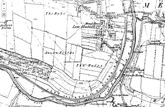
1858
At a time of pressure for modesty in local traditions, the Huttons
Ambo race for the bride’s garter, was adapted to become a chase for a ribbon (John Rushton, The History of Ryedale, 2003, 353).
1923
The Victoria
County History – Yorkshire, A History of the County of York North Riding:
Volume 2 Parishes: Huttons Ambo, 1923: Huttons Ambo is
bounded on the east and south by the Derwent, on the west by the little stream
of the Cram Beck. Of its area of 2,898 acres on a subsoil of Corallian Beds and Inferior Oolite 1,285 acres are arable
land, the chief crops being wheat, oats and barley, 1,371 acres permanent grass
and 166 acres woods and plantations. The high road from York leads north-east
through Huttons Ambo into New Malton, whilst the York and Scarborough branch of
the North Eastern railway runs through the south of
the parish. The land varies in height from 850 ft. above the ordnance datum at
High Hutton to 50 ft. on the river banks.
Bibliography