Loversall
The History of Loversall, south of Doncaster
|
Return to the Home Page of the Farndale Family
Website |
The story of one family’s journey through two
thousand years of British History |
The 83 family lines into which the family is divided.
Meet the whole family and how the wider family is related |
Members of the historical family ordered by date of
birth |
Links to other pages with historical research and
related material |
The story of the Bakers of Highfields, the Chapmans,
and other related families |
Dates are in red.
Hyperlinks to
other pages are in dark
blue.
Headlines of the
history of the Doncaster are in brown.
References and
citations are in turquoise.
Contextual
history is in purple.
The
area of modern Doncaster was likely not open land, but forested until it
started to be cleared in the late Saxon period. It has been described as the
Great Brigantian Forest. At some stage perhaps from
late Saxon times, areas were cleared for settlement in the process called
assarting. The growth of population and villages, including Campsall and Loversal,
by the time of Edward the Confessor suggest that assarting had been pursued
vigorously by that time (South Yorkshire, the
History and Topography of the Deanery of Doncaster in the Diocese and County of
York by Rev Joseph Hunter, 1828, page ix).Joseph
Hunter lists 170 vills of human settlement by the
late Saxon period. He suggested that settlement might have been influenced by
the need to cross a watercourse, but often may have
been the inclination of a family to settle on land, which larger grew into a
larger habitation. However he recognises that this
informal process was soon replaced by recognition of rights of occupancy from
the lands of the elite class who owned large estates. It therefore ceased to be
open to every citizen to clear woodland for his own use, but by the Doomsday
record, a right had been recognised in overlordship.
Thus Saxon lords came to surround themselves with
dependents who held portions of land from him, in return for rendering
services. This is reflected in culture such as Beowulf,
which provided an encouragement to live within the protection of the elite
class, as protection against the perils of unsettled places.
1003
The
larger seats of population came to be governed under the authority of a bors holder who was elected at a general assembly.
Townships were grouped in tens under a hundreder,
a superior officer who held courts. These hundreds came to be called wapentakes
in the areas to the north. Doncaster came to fall within the wapentake of
Strafford and Tickhill. Doncaster and Loversall fell within the
Wapentake of Strafford. Campsall fell
within the Wapentake of Osgodcross.
(South Yorkshire, the History and Topography of the
Deanery of Doncaster in the Diocese and County of York by Rev Joseph Hunter, 1828,
page xi).
1086
By the Norman Conquest, 28 townships in what is now South
Yorkshire belonged to the Lord of Conisbrough.
The Domesday
Book recorded:
“In Estorp, Earl Tosti had one manor
of three carucates for geld and four ploughs may be there. Nigel has [it] of
Count Robert. In the demesne, one plough and three villanes
and three bordars with two ploughs. A church is there, and a priest having five
bordars and one plough and two mills of thirty two
shillings [annual value]. Four acres of meadow. Wood, pasturable, one leuga and a half in length and one leuga
in breadth. The whole manor, two leugae and a half in
length and one leuga and a half in breadth. T.R.E.,
it was woth eighteen pounds, now twelve pounds. To
this manor belongs this soke – Donecastre (Doncaster)
two carucates, in Wermesford (Warmsworth)
on carucate, in Ballebi (Balby) two carucates, in Geureshale (Loversall) two carucates, Oustrefeld (Austerfield) two carucates and Alcheslei (Auckley) two carucates. Together fifteen
carucates for geld, where eighteen ploughs may be. Now [there is] in the
demesne one plough and twenty four villanes
and thirty seven bordars and forty sokemen. These have
twenty seven ploughs, wood, pasturable in places, in
places unprofitable”
So at the Conquest Loversall was a berewick of two caracutes in the
manor of Hexthorpe. Estorp (Hexthorpe) is a small
village now part of Doncaster and at the time about a mile downstream from the
town became an insignificant place after the Conquest and comprises three caracutes of land. However to
Hexthorpe were appended an extensive soke which included Doncaster
and Loversall and other places.
There is a suggestion from that Fulk de Lusoriis
had two bovates at Loversall and Geffrey Alselyn had
four bovates (South Yorkshire, the History and
Topography of the Deanery of Doncaster in the Diocese and County of York by Rev
Joseph Hunter, 1828, page 60).
Twelfth century
The church of St
Katherine dates to the 12th century. The simple interior of the nave
is supported by eight 13th century columns.
There was significant building of monasteries and parish churches
after the Conquest.
The building of churches was attractive since this allowed the
lords to extract tithes from distant churches to which it had been paid and
settle it on churches of their choosing, perhaps closer to their own residence.
During this period churches were built at places including Coningsborough, Campsall, and Doncaster.
Joseph Hunter lists 60 places where Churches were built.
Most of these churches had one officiating minister at their
foundation, the persona or rector. The churches were often placed
under the patronage of monastic institutions.
Certain of these churches were parish churches in form, but were also
referred to as chapels, which meant that they were given rights of baptism,
nuptial benediction and of sepulture, but were not able to participate in tithes from the lands around
them. These churches included St Mary Magdalene at Doncaster and the chapel at
Loversall.
1208
By the ninth year of King John’s reign, the Fossards
had erected a chapel at Loversall. Robert
de Turnham tried to recover the rights in the Doncaster church which Nigel
Fossard had given to St Mary’s Abbey, York, but had to acknowledge the
continued rights of the abbey, but was given a right
to the chapels at Loversall and Rossington, which
were part of the parish of Doncaster.
The vicar of Doncaster nominated the curate for the chapel at
Loversall. The chapel was originally a very small structure,
but was extended to a large chapel by the Wyralls
in the sixteenth century. There are several sepulchral stones from the earlier
age, associated with the Ripers, including an alter
tomb and the tomb of a child. Within the Wyralls
chapel is a tomb which might be that of William de Middleton.
(South Yorkshire, the History and
Topography of the Deanery of Doncaster in the Diocese and County of York by Rev
Joseph Hunter, 1828, page 60, 62).
1241
The Ripers family’s prominent status in
Loversall began in 1241, when the mesne lord William de Middleton passed land
to Robert de Ripariis.
By 25 Henry III, the mesne lord William de Middleton had passed
land in Loversall by fine to Robert de Ripariis or de Ripers,
in whose name ownership of the land continued until the sixteenth century.
Robert de Ripers also obtained others lands here from
the monks and abbots of Roche in exchange for other lands and £100.Robert de Ripers received lands and meadows at Wadworth, Alverley and Loversall, with their woods and mills, with an
annual rent of 27d. (South Yorkshire, the History
and Topography of the Deanery of Doncaster in the Diocese and County of York by
Rev Joseph Hunter, 1828, page 60 to 62).
By 1277, John de Ripariis was recorded as holding the fourth
part of one fee in Loversall. In Edward I’s
reign, the Survey of the County of York by John de Kirkby known as Kirkby’s Inquest, (the Nomina Villarum for Yorkshire)
was taken in the fifth reign of Edward I. It refers to Loversale.
De Johanne de Ripariis for the 4th part of one fee in
Loversale.
1331
Property and
local legal records indicate the family securely retained their status as Lords
of Loversall during the 1300s.
A legal record
from 1331 highlights a land arrangement (feoffment) involving a Robert,
son of John de Rypers of Loversall and his wife, Alice.
Feoffment by Adam son of Pain (Pagani) of Alworthlay,
to Robert son of John de Rypers of Loversall and Alice his wife in
survivorship, and the heirs begotten between them, of a messuage [in
Loversall]. Witnesses:—John de Rypers, lord of
Loversall, and others (named). Tuesday, the feast of St. John of Beverley, 1331 (Descriptive Catalogue of Ancient Deeds: Volume 5.
Originally published by His Majesty's Stationery Office, London, 1906).
1356
During the
fourteenth and fifteenth centuries, Robert Ripers (also recorded as de Ripariis or Rypers)
and his family were the dominant manorial landowners and gentry in the village
of Loversall.
1368
On 7 December
1368, patent rolls record that Robert Ripers transferred five acres of land in
the fields of Loversall to Sir William Farndale, a local chaplain. The deed
meticulously maps out the open-field system of medieval Loversall, referencing
boundaries like the Wykefield, Midelfild, and Wodfild.
A fourteenth
century table tomb stands in the churchyard. It is thought that a knight of St
John of Jerusalem is buried there, as such a person owned property in
Loversall.
1395
A 11391. Indenture
being a grant by Robert Twyer of Doncastre, Thomas
Chamberlayn, William de Wombewell, and John Frankys to Thomas Rypas of
Loversall and Joan his wife of the lands in Loversall which they had by his
gift and feoffment, those lands there and in Heghellers
excepted which they had granted by charter to Thomas son of the said Thomas
Rypas and Isabel his wife, in tail; to hold to the said Thomas and Joan for
their lives in survivorship with remainder, land in 'le Mydelfelde,'
&c. excepted, to the said Robert son of Thomas Rypas, in tail, with
remainder to Thomas' heirs, and with remainder as to the said land in 'le Mydelfelde,' &c. to the said Robert and Isabel, in
tail, with remainder to Thomas' heirs; attorneys to deliver seisin, [Thomas] Rypas of Doncastre or John de
Lee. Witnesses:—John Rypas of Doncastre,
Robert Rypas and others (named). 10 August, 9 Henry V. (1395?) Fragments
of seals. (Descriptive Catalogue of Ancient
Deeds: Volume 5. Originally published by His Majesty's Stationery Office,
London, 1906).
1427
By the fifteenth
century, the Ripers family consolidated their
influence through strategic marriages with other
powerful regional gentry. Records note that Thomas Ripers of Loversall had a
daughter, Ellen. Ellen married into the powerful Nottinghamshire gentry. She
married a prominent regional figure whose family served the estate of Knight
Edward Stanhope. This marriage produced two sons, Robert and Thomas. The Ripers family maintained continuous direct ownership of
their Loversall estates until the early sixteenth century. At this point, the
male line concluded or transferred its rights, and the manor passed to the Wyrall (or Wirrall) family, who
would later build the prominent Wyrall Chapel in the
local church.
Feoffment by William
Mar of Loversall to Robert Repas, John Yowll, John York and John Anten of
the same and the heirs and assigns of Robert, of a dovecot there. Lady Day, 6
Henry VI. Seal. (1427?) (Descriptive Catalogue of
Ancient Deeds: Volume 5. Originally published by His Majesty's Stationery
Office, London, 1906).
The physical
legacy of Robert Ripers and his family remains visible today at St Katherine’s
Church in Loversall. The churchyard and interior house several early medieval
sepulchral stones explicitly associated with the Ripers
family. Most notably, an early 14th-century chest tomb (now Grade II listed)
and the tomb of a young Ripers child survive as
physical testaments to the family’s high status and religious patronage in the
parish during the fourteenth century.
1848
A Topographical Dictionary of England. Originally published
by S Lewis, London, 1848: LOVERSALL, a parish, in the union and soke
of Doncaster, W. riding of York, 3½ miles (S.) from Doncaster, on the road to
Worksop; containing 159 inhabitants. The parish comprises about 2150 acres, of
which 720 acres, with the manor and Hall, are the property of the
Rev. Alexander Cooke, and 1300 acres that of Miss Elizabeth Banks; the
scenery is generally of pleasing character, and in many parts beautifully
picturesque. Loversall Hall, the seat of the Rev. A. Cooke, is a handsome mansion
of stone, in a well-wooded demesne. St. Catherine's, the seat of Miss E. Banks,
is a spacious and elegant structure in the later English style of domestic
architecture, embellished with porticos, turrets, and pinnacles, and
beautifully situated on an eminence commanding richly-diversified
prospects: in the grounds is St. Catherine's well, much celebrated in former
times, and from which the house derives its name. The substratum of the parish
abounds with limestone, which is quarried for the roads and for building. The
living is a perpetual curacy; net income, £53; patron, the Vicar of Doncaster.
The church, originally a small ancient structure, was enlarged in the reign
of Henry VIII., by the erection of a chapel on the south side of the
chancel, by the Wyrrall family: it contains an
altar-tomb over the remains of the founder; in the chancel is a recumbent
effigy of a knight, probably one of the Middleton family, and in the churchyard
is a tablemonument with a cross fleuri.
1857
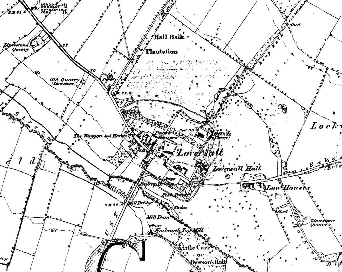
1857